Friday, July 24, 2009

Roger Williams Park hike


There are many wonderful hiking trails in Rhode Island, but most of them are at least a 45 minute ride each way from my house, so lately I have been trying to find walks that do not use a huge amount of fuel to enjoy.
One of my favorite places in urban Rhode Island is Roger Williams Park. http://www.rogerwilliamsparkzoo.org/visit/ParkGrounds.cfm
This park was developed in 1896, and is currently best known for its award winning and beautiful zoo. But besides the zoo, this park is still a treasure. In June I love to visit the Rose Gardens that are just inside the park if you are entering from the Elmwood Ave. side.
There is also an indoor merry-go-round, a japanese garden, a botanical garden, a wonderful playground for the kids, a museum of natural history which also houses a planetarium, a structure called The Temple to Music, many ponds, swanboats, the Casino which is a great place to have a wedding, the Betsey Williams cottage, the stable of the Providence Police mounted command division, and of course, an excellent place to take a hike!!!
Last month, Dan & I plus our niece Eryka and nephew Cory went to RW Park for a hike. We parked at the carousel, crossed the road at the crosswalk, and went over the lovely bridge. (Not the bridge pictured above, the above bridge is between the Betsey Williams cottage and the Casino.) Immediately after crossing the bridge, we took a right. There is a trail that hugs the shoreline.


We walked by this old beech tree, I just had to take a photo of it's above ground roots. This one is pretty old.


Also found this mountain laurel in beautiful full bloom.


This is my ham of a husband.


We followed the trail to the road near the Botanical Garden and crossed over to trek along the large pond. If you want to shorten the hike, you can turn right when reaching the road below the Gardens, which will take you by the Providence Mounted Command and the Dalrymple Boat House & back to the Carousel. Or you can take a left and walk towards the Museum and back to your car that way.

Here is the view towards the gazebo near the Botanical Gardens from the other side of the large pond:


I am not sure how long the hike is around the large pond, but it probably took us at least 2 hours total.

I found the above patch of blueberries, which I noted to my foraging brain to get back to later in the season.
Along the way we saw turtles sunning themselves on logs in the water, many water fowl, including this family of Canadian Geese, people fishing and enjoying themselves.


In the Temple to Music, this group of youth were either rehearsing a dance or a play, couldn't quite figure it out.
Once you pass by the Temple of Music, climb the hill, go accross 2 roads and then back down the hill to get to your car if it is at the Carousel.


Here is a shot of the Swan Boats. They are self propelled paddle boats and look like they could be quite fun, I have not checked on the price per hour yet.

Tuesday, May 26, 2009

Goddard Park Equestrian Trail


A couple of weekends ago, I had the good fortune of having a couple of hours to spend with my son and his baby's mama. As we were already in East Greenwich, we decided to go for a hike in Goddard Park:
http://www.riparks.com/goddard.htm

Goddard Park has many trails, and there is much variation with the seasons. It's close to my church and so we visit it often. The nice thing about hiking it with my son is that he used to have a summer job there when he was in High School as a Park Ranger, so he knows a lot of the history and the natural history of the park.

For this hike we parked across from the ranger station and walked towards the water, but going away from the back side of the bath house, so as to follow the trail along the Greenwich Cove part of the park. If you cut & paste the map link below, this hike followed the bridal path trail all along the cove, all the way to the Equestrian Center.
http://www.riparks.com/pdfs/Goddmap.pdf

On this trail you can look across the cove and see the waterfront area of East Greenwich, but also in the water you will see many waterfowl going about their business, depending on the time of year.
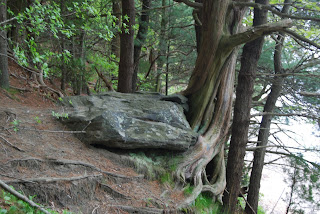
My son told me about an awesome cedar tree along this trail, and eventually we happened upon it.

I like how from this angle it looks like the tree is sitting on the rock and very peaceful looking:


But on this side, it looks like the rock is sitting on the tree and it looks like the tree is struggling with the rock:


We also came across this flowering bush, which I have not identified yet, but I think it is part of the rhodoendron family:


One of the historical things that my son talks about is that this property was legendarily used as a safe haven in the Underground Railroad. This structure sits next to an old ice house and is close to a low area that connects right to the cove. It is very well maintained and lovely to look at (and take photos of).


On the bridal path we saw these 2 horses, they were absolutely gorgeous. I am one of those persons who adoringly love horses and all their beauty, but am terrified of riding on them, so I like to take pictures. One of the riders gave us some tips about hikers sharing the trails with horses, so I thought I would pass them along for you to keep in mind while hiking in Goddard Park.

If you hear horses approaching, you should call out in a friendly manner so that the horses know that you are happy people, not monsters lurking in the woods.
If there is a group of you, you should not split to both sides of the trail, but should all go to one side of the trail so that you don't make them nervous.


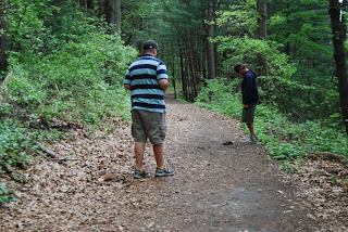
One of the things that the guys liked about hiking on the Bridal Trail were the many opportunities they had to play "Kick the Horsepoop Pile". One had an "artistic" way of doing it (his words, not mine), but the other one just liked to bash randomly so the game soon ended.


I love the many opportunities to examine different things to look at when I am out on a trail, don't you just love the shape of this deformity on this tree?


And the intricate manner in which these fallen cedar trees are so connected that it is hard to separate them with the eye. This trail is very shady from the many oak and pine trees that line it, but there is also a lot of fallen cedar along the edge of the embankment.


Towards the end of the Bridal Trail just behind the Equestrian center, we came into an area that had a wonderful amount of Lady's Slippers in bloom, we counted well over 50 plants in this area alone.


After reaching the end of the trail, we doubled back behind the Equestrian Center to find the road that loops through the park to take the short way home because our pregnant hiker was starting to get a little tired and still had her waitressing job to do that night. There are some very large grassy areas that we cut across to walk in a straight line where we saw some groups having picnics and playing games.

Just before we came to the golfing area we saw a large buck running. He was going ncredibly fast and we watched in amazement and tredidation as he leaped over 2 rock walls and made a beeline for Ives Road. Luckily he missed getting hit by any cars as he crossed that road and then leaped over another rock wall to go through the private property that is on the other side of that road. I have never seen a deer run so very fast, we are not sure what spooked him. And I was so scared for him that I could not even get my camera aimed to capture his beauty.

In this general area we found this beautiful sitting tree:


Our round trip walk was at least 2 hours, but you can shorten your walk by returning via the park road when you reach the parking lot at the boat ramp near the ice house.
This park is very busy on weekends during the summertime, but I have never been unable to find a spot to park my car. Also there are bathrooms open during the park "season" which I believe is the 2nd week in April through Columbus Day weekend. Near the Equestrian Center there is a pony ride for younger children, I do not know the cost of that, but I wish I was young enough to enjoy it, ponies are more my speed than horses.

Saturday, April 25, 2009

Touisset Marsh, Warren RI


On a recent Friday afternoon, I made arrangements with my sister and my brother to meet at Touisset Marsh after I got out of work. They were both off for Good Friday and I get out at noon on Fridays.
Touisset Marsh is in Warren, to get there take Route 103. If you are coming from RI(or heading east) it is just before the Rhode Island border, there is a brown sign indicating Audubon Refuge,you would turn right at the crossroads there. If coming from Massachusetts, take a left at the crossroads after crossing into RI. There is also a sign pointing the way. After that I did not see any signs, but follow this road, you will come to several bends in the road, and eventually you will see Touisset Road, take this road (you can only go right). This is a wonderful drive as there are many farms and beautiful trees along the way. At yet another left bend in the road, there is a small firehouse straight ahead of you, to the right of that there is a parking lot for the wildlife refuge.
While sitting here waiting for the other members of my family to arrive, there was a male cardinal singing out his praises to any female who might be interested. I spotted him in the top of a very tall tree.
After they all arrived, we set out on the trail that leaves straight out from the right edge of the parking lot. This takes you through a little stream and a low lying area that was quite muddy in areas, there are some boardwalks here in certain areas, but it had just recently rained so it was extra muddy. The reward for that was my first real glimpse of a dense concentration of green which is so immensely missed during the winter months.


After the wet area we walked through an area of tall trees and birds singing. There is a rock wall along the right (north) side of the property. Then we came to a very large open field, where we found some daffodils growing


this area is not marked, but you should be able to follow the well worn foot path around the perimeter of the field, which eventually takes you to the Touisset River. Of course the kids had to spend some time exploring here, and were quite amazed at the ribbed mussels that were growing on the on the mud flats along the river. Back on the trail, it leads into another area of open field along the river. When the kids went back to the beach further along, I spotted a great blue heron in the tributary that empties into the river, but he took off as soon as I lifted my camera to take a snapshot of him. The trail then turns to parallel the tributary, and there are a few areas that you can look out and hope to see egrets or great blue herons fishing for dinner here.

Of course if you have a gagle of noisy kids with you, it becomes difficult to see these types of birds so the photo below is from a previous visit when I was alone at this refuge.

On your left hand side there is a grassy marsh area and soon you will come to a lovely wooden bridge that spans the brook draining from the marsh. Take a peek over the side, sometimes you can see small fish or other creatures in the water under the bridge. Or maybe some very fresh kids:


After crossing the bridge you will be in a typical coastal tree area with sandy ground and cedar and swamp oak trees. In this area the older boy decided to play haunted forest with the younger kids and the adults dropped back to enjoy the almost quiet.


We came upon several interesting specimens in the trees. I took this photo of something I could not identify, but I believe it is a precursor of what grows on a maple before the leaves, I guess I've just never seen them because the amount of time they appear is very short. With some help from my friend Celia, I found out that they are the blossoms of a red maple tree.


My brother took this photo of a fungus growing on what I think is a juniper.


The fields in this area of the refuge border a quiet residential area, and on other trips I have seen many varieties of wildflowers. The kids found some large rocks among the trees and decided to play hide & seek. We came to yet again another large field area, and along the trail here there was wild green onions growing. The 6 year old was quite amazed that you could find onions growing out in the wild and he tried several for the novelty of it. After the onion field area we were once again back at our cars.
The trails and refuge are quite level and very child friendly, but not for a stroller. You can probably do this trail in an hour if you are just out for a walk, but if you are exploring with kids, plan on almost 2 hours.

Monday, April 20, 2009

Durfee Hill Management Area

We have one of those books by the late Ken Weber, More Walks and Rambles in Rhode Island, in fact we have 3 of his books and he never fails to get us lost. But silly me, pulled out his "More Walks and Rambles" two weeks ago to find a place to walk after church with our neice & nephew. We were supposed to take Route 44 west to Route 94, but before getting to Route 94 we saw a big sign for Durfee Hill, so we turned around and pulled into that parking lot. After having some leftover pizza for lunch, we took to the trail. The first part of the trail is pretty straight-forward, a wide trail with a small brook running alongside in some areas, some old apple trees and nice clearings off to the right. We even saw our first butterflies of the season, one a Mourning Cloak: http://www.simplybutterflies.com/Images/Butterflies/Mourning%20Cloak%20(2).jpg
and the other was a small white one. I was very surprised to see a butterfly so early (it was early April), but when I checked my field guide, it indicated that they fly early through leafless woods, and the range in New England starts in March.
Off to the left of the trail, probably about a quarter of a mile, there was a small man made waterfall, and the remains of an old foundation.
<
Shortly after the waterfall, we came to an intersection with the choices seeming to be left or right, but we should have gone straigt where there is a path, but it was not very noticeable because it is only a footpath, the other paths are made with trucks I think. Unfortunately, we took the left trail, which ended up in a clearing where some people had decided to have an outdoor art installation involving 3 televisions and probably shotguns, what a mess! This trail eventually ended in some very mucky grooves that looked like some yahoo with a motorized vehicle had gotten stuck. We returned to the intersection and took the footpath, which was quite nice and led us down to a nice body of water that I found out later was named "Burlingame Reservoir". I am not sure if it is an active reservoir at this time, I did not see any postings to indicate thus.


This was a very beautiful spot, and we spent some time just chilling here, breathing in the beautiful, sunny day, taking photos and exploring. There was a ladder going down into the dam area so of course Dan had to climb down and check it out:


After spending some time at the pond, we went to what would have been the right fork of the previously mentioned trail and this was a combination of tall trees, one nice trail that seemed to peter out after a while, and more areas for Dan to explore, namely a very old foundation.


After exploring in this area, we headed back to the car. You could probably spend some time checking out the old fields and other areas in this section of Durfee Hill, but I think that this may be a new area that has opened since Ken Weber wrote his book, when I check the DEM website, it indicated that there is 1176 acres to this management area.

Sunday, March 29, 2009

ROME POINT

Rome Point is a marvelous piece of land that used to be owned by the National Grid but is now the John Chaffee Nature Preserve, for directions click on the link:
http://www.dem.ri.gov/news/2006/pr/0413062.htm#direct

I like it when things like that happen, instead of nice places being bought by large corporations and being made into parking lots and towers of glass and steel.
Last Sunday we went on a "birthday hike" as my daughter-in-law called it, as my birthday was the very next day. It seems to be a tradition in our family. Along with me were my husband, both my sons and 1 daughter in law and our nephew. The quickest path to the beach is a straight pathway that is quite wide and goes directly to the beach, several people can walk together most of the time, and it is pretty level and easy to push one of those 3 wheeled strollers.


There are a few paths that veer off from the main path and one could spend a good amount of time to explore them all. But on this day I was on a mission, to see the seals, so we took the straight-away trail directly to the beach. Rome Point has the good fortune of having harbor seals winter on the rocks off of the point. The beach here is very rocky, but there is a great view to the south, where one can see the Jamestown Bridge and beyond.


On Sunday it was gray and overcast, but the lighting was gorgeous, expecially if you are into taking photographs, as I obviously love to do. To get to the area where the harbor seals are, take a left when you get to the beach, and follow the shoreline to the point. Along the way you will pass a beautiful marsh your left side that in the summer has red-winged blackbirds as visitors. There were quite a few families on the point doing seal watching on this day, and many happy dogs frolicking and making new friends. Dogs must be allowed at Rome Point, because I see people and their pals there all the time. My older son had a new camera, so he spent a good deal of time taking pictures and trying out th new zoom lens. The rest of us passed the binoculars to get a good look at the beauties on the rocks. There must have been about 30 of them on this day, what a gorgeous site.


After spending some time watching the seals and playing with the dogs, we took the trail that starts at the point and follows the curve of the shoreline of the cove next to Rome Point. This part of the trail has many cedar trees and old foundations and ruins. I think this area of the Preserve is the favorite of the men in the family, because there are many old dumping locations along the way, cellar foundations, one old rotted 50's station wagon

and we also saw deer poop and coyote scat. While the boys were digging around for treasures, the female in the medical field was worrying about tetnus shots. I think we determined that they are all due for their shots. The boys also found the remains of an old horse wagon. There are also several trails that can be taken off of this trail that meander around the property. One of the favorite spots of the younger kids in the family is a huge rock that is on this return trail just before you connect with the main trail. Usually we have to take photos on the rock, and this time was no exception, except that there was only one nephew with us this time.

this photo is from a previous hike


After passing this huge boulder, take the main trail to the right and follow it back to the parking lot.
There is room enough for 29 cars to park in the lot, but during the seal watching times it is usually full, and some cars end up having to park on the side of the road.
The photo of the kids on the rock and of the rotted station wagon are from old file photos of mine. The two close ups of the seals were taken by Jeremy Butterfield.

Monday, March 23, 2009

Caratunk

Last Saturday I went to Caratunk in Seekonk WITH some wildlife, hoping to SEE some wildlife. I met my brother & his family and my sister and her youngest son for a walk. Caratunk is part of the RI Audubon Society, but it is in Seekonk, Massachusetts.
I stopped in the little shed attached to the main barn to see if there were any trail maps for a gentlemen that was there who did not know the property. There were not any maps. There is a book to sign in there and also a little hole in the wall to put $ in. I deposited some $ and checked out the Whiteboard where people log the fauna that they have seen in Caratunk, but I did not get to read all of it because my 4 year old niece was demanding my attention.
We then went over to the kiosk, there was a large poster and explanation of the woodcock dance that they do at this time of year to attract mates. This is a very special thing to see and I believe Caratunk hosts members to see this display in evening gatherings. There were warnings about ticks and a list of other Audubon properties, but there was no map there either.
When I explore Caratunk, I usually start out on the trail that is to the right of the kiosk, but it was a little chilly so I thought we should head out across the meadow trail which starts next to the wildflower garden in front of the large barn. We followed this trail through the large meadow and through the opening in the stone wall and then took a right.

This trail led us through some woods and rock walls on our right, with another large meadow on a hill to our left. We took the trail that runs along the eastern edge of the meadow and stopped at the observation station. There we could see a hawk flying in the distance, but we could not make out what type of hawk it was. After everyone hydrated themselves and had some trail mix, we took off through a wooded area where there are ponds and brooks, several times stopping along the way to explore trees, rock, lichen


or moss and to play with sticks and the water. Overhead we heard some raptor noises and 2 of them were circling overhead, I am not sure if they were warning us to stay away from their nest or if they were just flirting with each other. I tried to get a photo of them, but they were very high in the sky. After showing this photo to my friend Dick Graefe, we have determined that it is probably a Broad Winged Hawk. Thanks Dick!
In this area of the refuge there is a pond on the left and a small brook running on the right.

From there we went up an incline and crossed the electric company right of way and continued our walk on the blue trail through some very boggy areas.


The last time I was here it was quite wet, but there has since been simple boardwalks put in which will protect fragile fauna and flora, and also keep your shoes out of the muck. We could hear noises in one of the vernal ponds that we were adjacent to. I had the kids stop and listen and asked them to guess what the noises were. One guessed geese and the other 2 didn't know. This was my first hearing of peeptoads for the year, one of the best noises one can hear to signify that spring is indeed on its way, and admittedly, one of my favorite songs.
We followed the blue trail in this part of the refuge, through some hemlock, until we came to an area where the trail markings just seemed to disappear so we retraced our steps back to the boardwalk over the vernal pool. My sister-in-law and I got there ahead of the kids and we were able to more thoroughly enjoy the beautiful harmonies of the peeptoads. We also tried staying very still to see if we could get them to think we were not there and perhaps they would stick their eyes up out of the water, but too soon the children arrived


and we could not coax them at all to stand like statues, so we didn't get to see the rascals.
We got back to the electric company right of way and took the meadow there further south to catch the trail on the other side of the refuge. Along the way Terry and I saw a small bird on top of a birdhouse, but we could not make out what it was. I wonder if it is too early for bluebirds. The connector trail here is very difficult to find, and I did not see it until I was right on top of it. The return trail going to the lower section of the refuge is narrow and can be a little steep in some areas, so caution with your footing must be taken. This section is populated by glacial erratics


and the brook that winds throughout the property. We stopped here for a rest (the adults) and for some playing in water with sticks time (the children). The 13 year old decided to walk across the brook on a log that is there and he was successful on the first try, but on the return of the second try he lost his footing and landed very ungracefully, thoroughly soaking the front legs of his jeans.
After the drama involving that and some concern (by the child, not the parents) that back surgery would be imminent, we once again took to the trail. Someone found a snake,and all the other members of our party marveled over it while I stayed a safe distance of at least 150 feet away. I have a huge phobia of snakes and cannot bear to even look at them, or pictures of them.
The trail here winds through some large rocks, one of them being named as Monument Rock and some dead cedars. We came to another little wooden bridge over the pond where the kids found some leeches and my 4 year old niece had a mild spaz attack when she picked up a rock and found some very miniscule baby leeches.
We then took the trail that follows the edge of a golf course and through some very tall red pines, where there is a lot of pine needle carpeting, coming to yet again another bridge over the brook. At this bridge there were 2 young people sitting and one standing next to the bridge. The standing person told me I'd have to pay a toll to cross the bridge. I asked him if he was the troll under the bridge and he said yes, and the payment to cross was one smile, so we were allowed to proceed. Taking a left after the bridge to walk back to our cars, I could hear a male cardinal making himself known to all the lady cardinals, so Terry and I checked the tree tops until we spotted him, a beauty at the top of the highest tree.
After we returned to the car and I checked the time I realized that we had been exploring for over 3 hours. This trail can be done in a shorter period of time, but I think it was just right.